BURKESVILLE SOUTH ROADCUT
A spectacular disconformity
occurs along both sides of Rt. 61, south of Burkesville, south-central
Cumberland County, southern Kentucky, USA. The roadcut is a little south
of a Rt. 61 bridge over the Cumberland River, ~9 miles north of the
Kentucky-Tennessee border.
Looking ~SE.
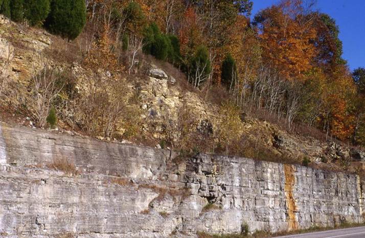
The light gray unit in the
lower part of the cut is the Cumberland Formation (Upper
Ordovician). It is overlain by brownish-weathering Chattanooga Shale
(Upper Devonian).
The Cumberland Fm.
here is a silty dolostone. The sedimentary structures and fossils present
in the Cumberland include mudcracks, horizontal trace fossils, ostracods,
small-scale cross laminations, scarce isolated ripples, small scours, rip-up
clasts. These features indicate deposition in marginal marine to
intertidal zone facies.
The overlying Chattanooga
Sh. here is a black shale unit (equivalent to the Ohio Shale & New
Albany Shale - both also Upper Devonian). It has a fair amount of
disseminated microcrystalline pyrite. With oxidative weathering, the
pyrite alters to iron oxides and hydroxy-oxides, which stain the shales
brownish to yellowish-brown to whitish. Bedding planes with compressed,
carbonized Foerstia fossil algae (aka Protosalvinia) are not
uncommon in the Chattanooga here.
The Cumberland-Chattanooga
contact is a bleeding unconformity. Notice the white streaks &
the rusty orange streak on the Cumberland dolostones. These are the
result of staining by downward-seeping rainwater carrying iron oxides and iron
hydroxy-oxides.
Note the ages of rocks above
& below the unconformity (disconformity). The entire Silurian is
gone, as is the entire Lower and Middle Devonian. Close to 70 million
years of Earth history are unrepresented in this section!
BURKESVILLE
SOUTH Roadcut
Fossiliferous limestones of
the Ft. Payne Formation (Lower Mississippian) are well exposed along a
Rt. 61 roadcut south of Burkesville, a little south of the Cumberland River,
and about 8 miles north of the Kentucky-Tennessee border, Cumberland County,
southern Kentucky, USA.
This is a great place for
seeing lateral facies change. Note the folded rocks in the center of the
photo shown below. It looks like an anticline. But note that
the overyling rocks at the top of the cut are horizontal. This ain't an
anticline. The structure at bottom-center is a mud mound.
The limestone beds above have draped over the mound, and the flank beds are
thicker - this mound is an original, primary feature.
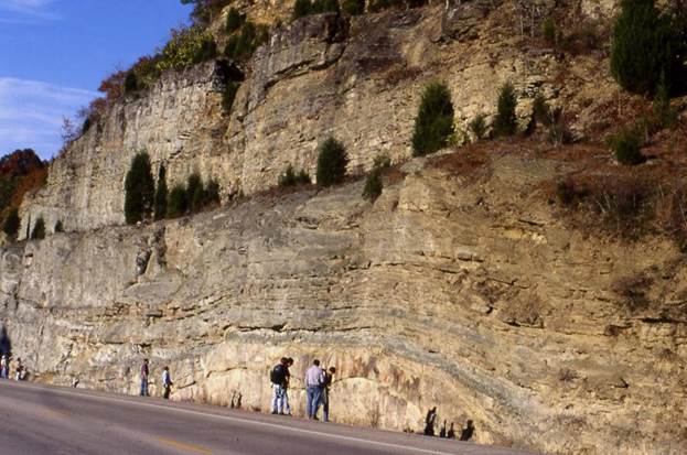
Ft. Payne Formation. Looking ~NE.
The Ft. Payne Formation is
about 270' thick in this section. Mounds and buildups are relatively
common in the Ft. Payne Formation of southern Kentucky. They are best
examined along the shores of nearby Lake Cumberland. The Ft. Payne is
mostly early to middle Osagean in age (late Early Mississippian), but the basal
parts of the unit may be Kinderhookian in age (early Early Mississippian).
Crinoids are the most
abundant fossils in the Ft. Payne Formation. Decent crinoid heads can be
found relatively easily throughout the Ft. Payne in southern Kentucky. I
found crinoid head material & blastoid head material during visits to this
roadcut.
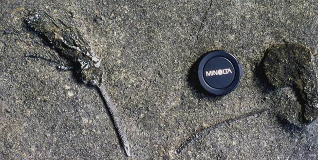
Ft. Payne Formation - articulated camerate
crinoid fossils in fossiliferous limestones exposed along the shores of Lake
Cumberland, southern Kentucky, USA.