Platystrophia ponderosa with
GEOPETAL
STRUCTURE
Geopetal structures are geologic features that indicate the original orientation
of gravity-defined “up” and “down” at the time of rock formation. The
specimen shown below is a broken orthid brachiopod shell (Platystrophia
ponderosa Foerste, 1909; Animalia, Brachiopoda, Orthida, Platystrophiidae)
containing syndepositional and post-depositional material that infilled the
shell after decay of soft tissues. The light- to medium-gray material in
the lower two-thirds of the shell is lime mud (sedimentary micrite). The
whitish to pale yellowish-gray crystals in the upper third of the shell are calcite.
Note that the calcite crystals have not completely filled up the available
empty space.
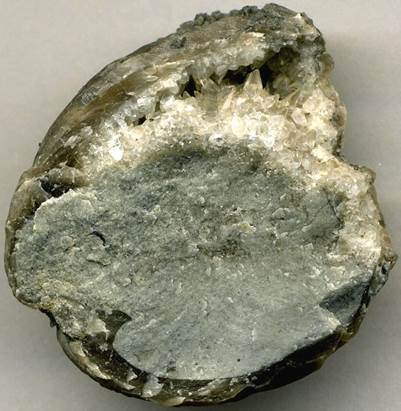
So, which way was up? At the time of final
deposition, the shell was oriented in the position you see it now. The
calcite crystals are partially filling what was originally water-filled empty
space in the shell. Not enough lime mud entered the shell interior to
fill it up, so the mud obviously accumulated in the “down” portions of the
shell. The “top” portions of the shell were left empty, until diagenetic
or post-diagenetic fluids that were rich in dissolved calcium carbonate
precipitated the calcite crystals.
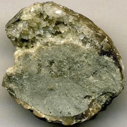
Geopetal structure inside Platystrophia ponderosa brachiopod
shell (2.8 cm across) from the Upper Ordovician of northeastern Kentucky.
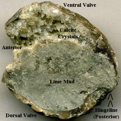
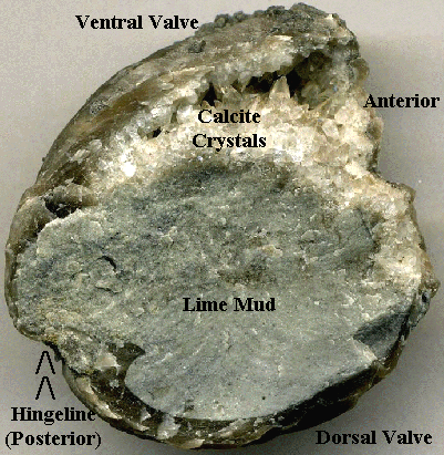
Interestingly, the up-and-down orientation indicated
by the geopetal structure is not the brachiopod’s biologic up-and-down
orientation. The dorsal shell (biologic up) of this fossil sits below the
lime mud accumulation. The ventral shell (biologic down) sits above the
calcite crystals.
The brachiopod’s preferred life position, however,
most likely had the anterior end facing upward and the hingeline area facing
downward.
Stratigraphy: float from the Bellevue Limestone, Maysville Stage, middle
Cincinnatian Series, Upper Ordovician.
Locality:
loose piece from upper portions of the Maysville West outcrop (= large roadcut
through Jersey Ridge along the Rt. 62/Rt. 68 bypass west of Maysville - the 1st
hill south of Harsha Bridge over the Ohio River), northern Mason County,
northeastern Kentucky, USA.