MICHIGAMME FORMATION
The Michigamme Formation is
the uppermost unit of the Marquette Range Supergroup, a thick succession of
Paleoproterozoic metamorphosed sedimentary rocks, ranging from
metaconglomerates to metaquartzites to metadolostones to slates to
iron-formation. The Michigamme outcrops throughout a large synclinal
structure in the vicinities of the towns of Marquette, Negaunee, Ishpeming, and
Michigamme. This large syncline is called the Marquette Trough.
The Michigamme Fm. is
moderately heterolithic, consisting of up to six members of varying lithologies
in places. The upper slate member and lower slate member make up the bulk
of the formation. They contain slates, phyllites, and finely crystalline
schists. They represent metamorphosed shales and graywackes (dirty
sandstones), generally interpreted as deep-water marine turbidites (Cannon
& Klasner, 1977; Klasner & Cannon, 1978). The unit also has some
iron-formation in three of its members. In places, the Michigamme has a
member with metavolcanic rocks (Clarksburg Volcanics Member), including
metatuffs, volcanic metabreccias, and lava flows altered to amphibolite.
Stratigraphy & Age: Michigamme Formation,
upper Baraga Group, uppermost Marquette Range Supergroup, upper
Paleoproterozoic, ~1.85-1.86 billion years.
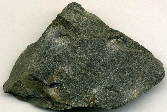
Staurolite schist (5.6 cm across at its
widest) from the Michigamme Formation at a roadcut along Cardinal Road, just S
of the western end of Lake Michigamme, western UP of Michigan, USA (see
map). This rock has crystals a bit too small to really qualify as a
schist, but they're a bit too large to really qualify as a phyllite. The
indentations at the top and a couple of the bumps in the lower part of the rock
are where staurolite crystals have popped out.
Some info. from:
Cannon & Klasner (1977)
- Bedrock geologic map of the Diorite and Champion 7½-minute quadrangles,
Marquette County, Michigan. United States Geological Survey
Miscellaneous Investigations Series Map I-1058.
Klasner & Cannon (1978)
- Bedrock geologic map of the southern part of the Michigamme and Three Lakes
quadrangles, Marquette and Baraga Counties, Michigan. United States
Geological Survey Miscellaneous Investigations Series Map I-1078.