MT. ST. HELENS
The 1980 Mt. St. Helens eruption was the largest in
recent American history. Following a large
eruption in May 1980, this volcano was intermittently active until
1986. Minor activity occurred from 1989 to 1991 and from 2004 to 2006.
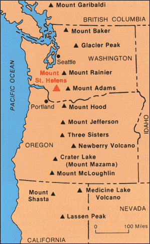
Mt. St. Helens is the most active volcano in the Cascade Range, a series of
subduction zone stratovolcanoes in a ~north-south line from northern California
to Oregon to Washington State to southwestern British Columbia. St.
Helens is a 40,000 to 50,000 year old, andesitic-dacitic-basaltic volcano that
typically has explosive ash eruptions (as do all subduction zone
stratovolcanoes).
The 1980 eruption was a northward-directed lateral
blast that followed an enormous landslide of the northern face of the
volcano. The landslide was triggered by a moderate earthquake at 8:32 AM,
Sunday, 18 May 1980. Snow and ice on the mountain melted during the
eruption, mixed with ash and other debris, and rushed down nearby river valleys
as lahars (volcanic mud flows).
The ash, lapilli, and pumice erupted from Mt. St.
Helens in May 1980 was dacite, an intermediate extrusive igneous
rock. Most of the air-fall dacite ash fell in Washington State, Oregon,
and Idaho, but a minor amount accumulated as far east as Minnesota and
Oklahoma.
Location:
Mt. St. Helens, northwestern Skamania County, southwestern Washington State,
USA (46˚ 12’ 04” North, 122˚ 11” 18” West).

Dacite ash (ash fall deposit) (field of view ~5.1 cm across) from the 18 May 1980
explosive ash eruption of Mt. St. Helens. This ash was collected at the
town of Yakima, northern Yakima County, southern Washington State, USA.