A Look at Biotic Events at High Southern Latitudes at
the End of the Cretaceous
William
Zinsmeister (Department of Earth and Atmospheric Sciences, Purdue
University, West Lafayette, Indiana)
Ohio State University, Columbus, Ohio
19 November 1998
The
Cretaceous-Tertiary (K-T) extinction is the smallest of the big 5
extinctions. 11% of all families go extinct at the K-T boundary.
But, the K-T extinction is a favourite of many people, mainly because it
included the extinction of the dinosaurs. There have been many theories
proposed about why the dinosaurs went extinct, including mammals eating their
eggs, the evolution of angiosperms interfering with their digestive systems, and
other ideas.
But,
all these dinosaurs extinction hypotheses are flawed because they only deal
with dinosaurs. Many terrestrial and marine groups (plant and animal)
went extinct at the same time.
Then,
the impact hypothesis came along in the early 1980s by the Alvarez’. This
idea explained the K-T extinction in both the terrestrial and marine realm -
basically, the global food chain collapsed. Also, the impact theory
caught people’s imaginations, and was immediately accepted as fact by the media
and the general public. There is much debate among scientists, though.
Now,
there is much compelling evidence for an impact. Lots of computer
modelling has been done to see what an impact would do the the Earth. One
idea is that debris would be thrown up high into the atmosphere and would fall
back down as an enormous meteor shower, which would heat the atmosphere to
800˚ and everything on the surface was cooked. Other scary ideas:
rainshowers of nitric acid and sulfuric acid, nuclear winter scenario, and
global forest fires.
Problem: If things
were so bad, how did anything survive? Where are the burned/charred
dinosaur bones and trees if all this happened?
There
are a few diehards who still say an impact didn’t happen.
Other
than that, there are 2 hypothese: 1) Bad Day Hypothesis; 2) Impending Doom
Hypothesis.
The
Impending Doom Hypothesis says that the Earth’s biosphere had been under a long
period of stress up to the time of the impact. The impact was the
capstone to the extinction. This seems like a logical idea.
Seymour
Island - is near the northeastern tip of the Antarctic Peninsula. The
geology on Seymour Island is mostly a homoclinal succession of rocks -
Cretaceous to upper Paleocene.
Post-impact
scenarios - it has been difficult to assess post-impact scenarios because there
are few areas in the world with Danian-age rocks. Danian rocks occur in
northwestern Europe, a few other places, and on Seymour Island. The north
part of Seymour Island is Tertiary in age.
There
are about 70 km2 of outcrop to look at on Seymour Island (upper
Cretaceous and lower Tertiary). The island has a desert-like topography
similar to southwestern USA. These are good exposures, and they are
packed with fossils with a high diversity and good preservation. About
800 species of fossils have been described from Seymour Island. Lots of
ammonites are just lying on the surface. The ammonites are
aragonitic. There are also good gastropods and bivalves (all fresh
looking). There are also fossil echinoids (including 1 form with 5 brood
pouches - the juveniles live in the parent up to a certain point). There
are also plesiosaurs and mosasaurs. Ammonites are common.
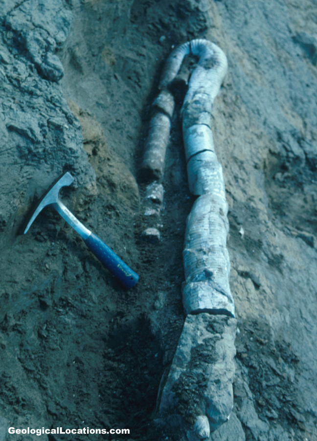
A
spectacular specimen of Diplomoceras
was found last year - a specimen that was 1.5 meters long (but curved;
uncurved, it would be 14 feet long). The animal itself was ~6’ long (a 6’
long living chamber). Smaller pieces of this fossil are relatively
common, but this specimen was unusually preserved. It is the nicest, most
remarkable specimen known.
Seymour
Island is very muddy to work on - it is always above freezing during the field
seasons.
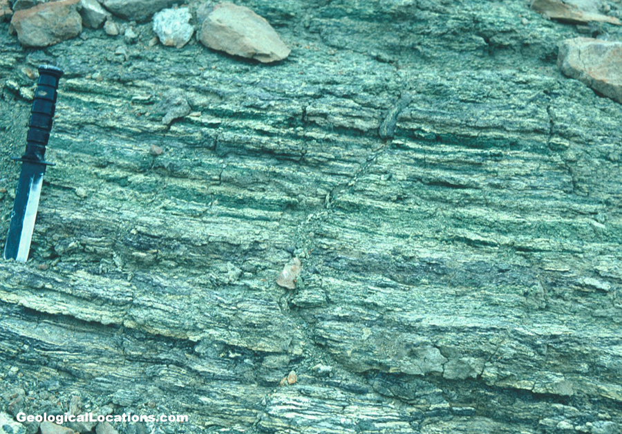
An
iridium anomaly does occur here on Seymour Island. It occurs in a unit
referred to as the K-T
glauconite, which is a greenish, glauconitic sandstone that occurs at the
boundary. The glauconitic sandstone is easily correlatable across the
island.
There
are no stratigraphic or sedimentological signatures at the K-T boundary.
There is no boundary clay, as seen at Gubbio, Italy.
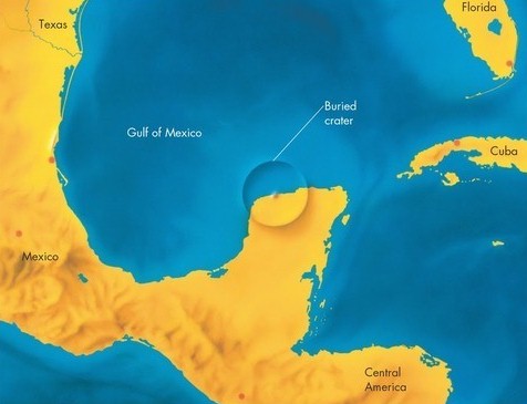
Antarctica
is ~8000 miles away from the Chicxulub
Crater in Yucatan, Mexico, which is a significant point as far as
considering the after-effects expected to be seen in Antarctica.
Rudist
record - there is a gradual increase in rudist diversity in the
Cretaceous. Most rudists went extinct at 68-67.5 my (~early-late
Maastrichtian boundary). This pattern mirrors other groups’ diversity
patterns as well - all mostly go extinct before the K-T boundary.
Seymour
Island ammonites crash at the end of the Campanian. Seymour Island inoceramids are
gone near the end of the Campanian. Seymour Island belemnites virtually
disappear at the end of the Campanian. Seymour Island ammonites are quite
diverse in the Campanian (35-36 species), but their diversity crashes to 10
species in the Maastrichtian, and they are gone at the K-T boundary.
Several Campanian cosmopolitan ammonite families disappear in the Campanian in
the Seymour Island area, but they extend to the K-T boundary in lower
latitudes. So, their disappearance in the Seymour Island area indicates a
general temperature decline (cooling).
A
regression occurred at the mid-Maastrichtian.
Superimposed
on the Maastrichtian temperature decline are several rapid warming
spikes. 50,000 years before the K-T boundary event was a warming event,
documented from some ODP sites.
Note
the restricted occurrence to 1 horizon on Seymour Island of the ammonite Zealandites
varuna in the Maastrichtian Lopez de Bertodano Formation. Its
presence probably represents a warming spike.
The
faunal transition across the K-T boundary on Seymour Island - no single
extinction event seen - a gradual decline is seen instead. There is no
marked extinction horizon.
Then,
someone suggested that this pattern is due to the Signor/Lipps Effect, a
phenomenon produced by collection/preservation biases. One can get a
gradual extinction pattern purely due to collecting and preservation
biases. So, Zinsmeister and others recollected the fossils on Seymour
Island, and collected fossils spatially, doing detailed mapping.
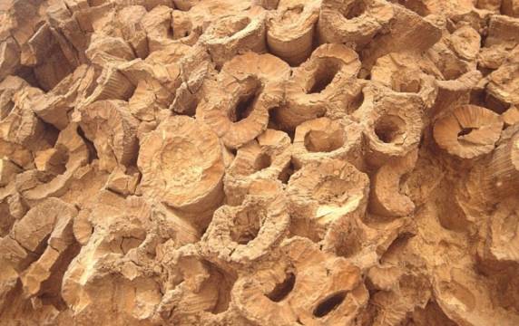
The
K-T glauconite (~5 meters thick) is actually 3 units - a lower glauconite, a
middle fish bed/horizon, and an upper glauconite. The fish debris bed
could represent a victim bed from the K-T impact.
The
new diversity record from renewed collecting of fossils: the extinction is less
gradual now, and more abrupt, but all groups are dying out just before the
iridium anomaly. The K-T extinction is now more abrupt is high southern
latitudes than previously thought.
Fish
horizon - interpreted to be the effect of extreme ocean disruption; fish kills
are not due to ocean poisoning (strangelove ocean), but by pulses of nutrients
into the oceans. This is the only fish horizon in 1600 meters of
section. It could be an interval of slow deposition, but this is not
likely because fish degrade relatively quickly, and one needs special
conditions to preserve fish. The fish debris bed represents conditions
after the K-T event - lots of fish kills occurred.
The biosphere is far more
robust than we give it credit for. Organisms have been able to survive
truly catastrophic events in geologic history.
Example: the Millbrig Bentonite
(Middle Ordovician, eastern USA and Scandinavia). This eruption resulted
in no extinctions. Therefore, Earth’s biosphere is very robust.
But, if the biosphere is alrady stressed, then a big event can push the biosphere
into a mass extinction.